I spent a week visiting family in California when I returned from Thailand and then flew to Las Vegas to spend Easter with Maureen and her family. I returned to Connecticut in early April with the intention of finishing my taxes and then heading back out onto the AT. It was still cold and rainy though and I decided to go to Miami Beach for a few weeks and get back into shape in a comfortable climate. The weather in Miami was great and through a combination of diet and exercise I was able to lose 20 lbs. I ran a few miles every day on the beach. The rip currents were very strong and several people drowned during my stay there. I flew back to
Connecticut on 5/17 where I stayed for a week before hopping on a bus to
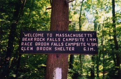
North Adams, MA to resume hiking the AT southbound. I stayed at The
Williams Inn the first night and started hiking on Wednesday 5/26. The
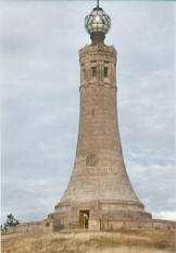
first day I hiked up to Bascom Lodge on Mt. Greylock – a nine-mile day
uphill. Mt. Greylock is the highest point in
Massachusetts at 3491 feet. The climb was much more difficult that I had
anticipated and I paid the price for not being in better shape. It’s been
awhile since I’ve had a 50 lb pack but with Mt. Greylock behind me, I hope to
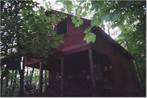
get my hiking legs back in a few days. Bascom Lodge is pretty nice. For $26, I had a bunkroom (to myself) and received an excellent dinner and breakfast. Several people came and went during the afternoon, but I was the only overnight guest. An interesting feature of Mt. Greylock State Park is the Hoosick Railroad Tunnel, which was built 150 years ago, and at 4 ˝ miles was once the longest tunnel in the world. It connected the railroad line between Albany and Boston. I understand a couple relatives from the Brown side of my family helped to construct the tunnel. I woke up at 4:30 AM Thursday and was surprised to see that, although foggy, it was already light outside. I threw a few logs on the dying fire downstairs and finished drying my clothes, which were still damp from the day before. At 7:30 AM, I ate breakfast, packed and left. It took seven hours to hike the 17 miles (mostly downhill) to Dalton, MA. I stopped by the Dalton Library to use the Internet and then checked into The Shamrock Inn for the night. On Friday it was raining and my legs were very tight so I decided to stay in Dalton for another night. This being Memorial Day Weekend, it will be difficult to get last minute motel reservations so I’ll plan to camp out until at least Monday night. Saturday, 5/29, I left Dalton at 10:00 AM and spent an excruciating six hours hiking eleven miles to October Mountain Cabin. The weather was a little cool and breezy but the sun was shining. My legs are still very tight. When I arrived at the lean-to at 4:00 PM I got right into my sleeping bag and turned in for the night. Some other folks showed up around 6:00 PM, but they pitched a tent about 100 meters up from the cabin.
I arrived at Goose Pond just before noon and met the caretaker – Mary Pat – who was starting her one-week volunteer shift today. She was heading to town (she had a car parked a couple miles down the blue blazed trail) and offered to get me a sandwich while she was there. I stayed and chopped wood for a while and then spent the afternoon reading. A dozen other hikers came in during the afternoon but only four of us stayed inside the cabin, the others preferring to pitch their tents outside. I built a fire in the evening and Mary Pat brought out cookies & marshmallows. I went to bed at 9:00 PM. Monday was Memorial Day and the two-year anniversary of my retirement. Mary Pat made pancakes for everyone and I gave her a nice tip, as I am sure she was spending her own money to feed us. I packed and was the first to leave at 7:30 AM. The weather was good, however, the forecast called for increasing clouds and rain coming for the next couple days. I hiked with only a couple breaks covering 19 miles in eight hours to MA Route 23 where I hitchhiked to Great Barrington and checked into The Days Inn. My legs felt good today and I think they’ve got used to the hiking. I did feel some back spasms though, which are very painful and probably developed from the heavy backpack. It rained during the night and I decided to stay here in Great Barrington for a couple days. Tuesday, June 1st, I had breakfast at the hotel’s lobby and then walked to town to do some laundry. I found a couple of Internet points but none of them were able to access AOL so I was unable to check my email. The day turned out to pretty good weather wise and I felt a little guilty for not hiking. On Wednesday, I took a taxi back to the trailhead on MA Route 23 and slack-packed twelve miles over East Mountain to MA Route 41. I finished before noon, but that was to be expected, as I did not have a backpack. I looked around for any Internet access along Route 41, but came up empty so I hitchhiked back to Great Barrington. In the evening I walked to town and had dinner at a nice little bistro, which seemed popular. It started to rain again just as I was leaving the restaurant and I got soaked on the way home. Thursday, June 3rd, I ate breakfast, checked-out of The Days Inn and took a taxi back to the trailhead on MA Route 41 where I had stopped yesterday. The weather was good and I looked forward to a ten-mile hike over a couple 1500-foot mountains en route to Bond Lean-to. I felt good as I climbed up over 2500 ft Mt. Everett, passing several groups of school age kids out for a day hike. Things started going downhill as I passed over the summit and the sky all of a sudden darkened and it started to pour. It only rained for an hour, but I got drenched and the trail became very slippery. My back started giving me trouble again and I needed to be very careful not to twist my torso.
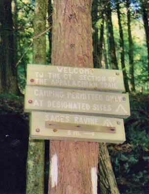
At this point, I was feeling pretty miserable. Both feet were soaking wet, my back hurt and I had a 1,000 ft ascent and 4 miles to go before reaching Bond Lean-to. Nevertheless, I pushed on and reached the lean-to a couple hours later at 5:00 PM. It had taken nine hours to cover 14 miles. On Friday morning my boots were still wet so I decided to take it easy and head for the nearest town for the day. I packed up early and left the lean-to before 6:00 AM. I hiked five miles downhill to CT Route 41 and then walked an additional mile into Salisbury to find a place to stay. I passed by an Inn and found they wanted $200/night, but they referred me to Barbara Ardasen’s B&B in town where I was able to get a room for half that amount. After dropping my pack, I showered and then walked to the town center. There was a library with a plaque stating that it was the oldest public library in the country. Fortunately they had a nice computer system that enabled me to check email. I enjoyed coffee in the local coffee shop and then bought some food at the grocery store and headed back to the B&B. I am the only guest today. Barbara is busy gardening and working with her antiques business. I looked through some of her extensive books on antiquing, but spent most of the day relaxing and reading. There are no restaurants in the immediate area and Barbara offered to drive to the next town to pick up Chinese take-out, which we enjoyed together for dinner in her kitchen. She offered me the opportunity to stay another night at no charge and although it was tempting, I was anxious to move on. I woke up at 5:00 AM Saturday, packed and tried to leave without waking Barbara. Her miserable little dog (who had eaten my guacamole flavored Doritos last night turning his face bright green) saw me and started barking which I am sure woke not only Barbara but neighbors on both sides. I headed back out CT Route 41, turned south on the AT and started my ascent of Barrick Mattif. It was a cool day and the forecast was for 30% chance of showers. By this time I was into a routine of hiking 2 ˝ hours at a time punctuated by 15 minute breaks. In the late morning, I started hearing the roar of racecar engines and know I was close to Lyme Rock Raceway. I could hear the cars for almost four hours as I hiked over the mountains, which overlook the valley where the track is laid out. There was only one place on the trail from which I could actually see the track and I watched for a few minutes. At about 2:00 PM, I reached Pine Swamp Brook Lean-to, my destination for the night. I had hiked 17 miles and was pretty tired. The lean-to was crowded with people eating lunch when I arrived, but the all left after awhile and I was alone for a couple hours until four additional hikers showed up to spend the night.
I had planned to hike to Kent tomorrow and spend the night at an inn there, but after calling around, I found that this was graduation weekend at The Kent School and no rooms were available. After considering my options, I decided to stay at The Hitching Post Motel in Cornwall Bridge for a second night and spend Monday slack packing down to Kent. I was up and out by 6:00
AM and stopped at the store for coffee on my way out Route 4 to the
trailhead. Without a backpack, I was able to hike the 12 miles to Kent
in four hours.
Tuesday morning, the motel owner, Mr. Patel, gave me a ride back to Kent where I picked up the trail on Route 341 where I had left off yesterday. I started hiking at 7:40 AM and had an immediate 1000 ft climb up Mt. Schaghticoke. The weather is hot and by 8:30 AM I am completely drenched with sweat. After slack packing yesterday, my pack seems much heavier than it actually is. The trail briefly enters and then exits New York State, but by 2:00 PM I had crossed Route 55 and left Connecticut behind for good. I was real tired due to the heat and humidity. I had hoped to get to Route 22 where I would hitchhike into Harlem Valley for the night, but when I reached the Wiley shelter, I decided to stop for the night and hike into town tomorrow. A few other hikers came to Wiley Shelter during the afternoon. I ate a couple sandwiches and finished book 5 of ‘The Lord of the Rings’ I went to bed early but had a terrible time sleeping as my back continued to bother me. Wednesday morning I got up and was hiking by 5:30 AM. I decided to hike only five miles to Route 22 where I would find a motel to wait out the heat wave and allow my back to recover some. I had to step over a deer that had died right on the trail about half way to the road. When I got to Route 22 I walked south for half a mile to a small store where I learned that the only motel was three miles in the opposite direction. A store employee was heading that way and offered to give me a ride.
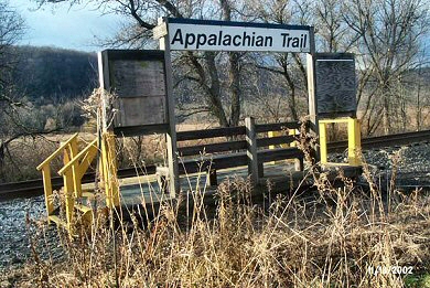
Thursday, June 10th, I got a slow start and did not leave until after 10:00 AM. I was only planning on going 10 miles today and with rain threatening, I figured it would be more comfortable in the room. A taxi took me down to the trailhead. The railroad track crosses the AT at the trailhead and there is actually a station stop in the woods with the name ‘Appalachian Trail’. I was climbing West Mountain by 10:30 AM and passed Nuclear Lake. I had planned to go to Morgan Stewart Shelter today, another ten miles tomorrow and then fifteen more on Saturday. When I reached Route 55, however, I decided that my back pain was too much for me to enjoy hiking and I would stop here and come back when I felt better. I hitchhiked to Pawling where I got a train to NYC and then back to Stamford. In Stamford I rented a car and drove to Fairfield. I’ll pick up the trail again in the future. |