 |
Hawaiian Journal Fall 2005 |
|
|
Hawaiian Journal Fall 2005 |
|
On Oahu I rented a car, picked up hiking and camping permits in Honolulu and then drove around to the windward side of the island where I had made a reservation to camp the first night at Malaekahana Campground in Laie. I shared my oceanfront tent site with about a dozen chickens, but other than that, I was alone. It rained during the night and appeared that the rain would continue on Wednesday so I decided to move to a motel for a couple nights. The Laie Inn is squeezed in between Brigham Young University's Hawaii Campus and the Polynesian Cultural Center which BYU owns. I could not get into my room until 3:00 PM, so I drove over to the North Shore to see if anything was happening at the Banzai Pipeline, Oahu’s most famous surfing beach. Unfortunately, the waves were only 5-6 feet so the surfing was not too interesting. I spent a couple hours at the beach reading James Mitchner's Poland, which I still have not finished from my trip to Eastern Europe last month. I've got three books on Hawaii with me and need to start learning about New Zealand & Tasmania ahead of my trips there in January. I must either be reading too slow or traveling too fast. Thursday morning I drove a couple miles south to the Hauula State Forest where I planned to hike two, 2 1/2 mile loops up into the forest. I had been warned about high incidents of automobile vandalism and theft in Hawaii so I decided to park in a more public shopping center parking lot and walk the extra half mile to the trailhead. The trail itself was rated easy, but the intense humidity made it more difficult than I anticipated. After completing the first Hauula Loop, I decided to save the other one for tomorrow. I returned to my hotel, showered and then went to the Polynesian Cultural Center. I spent the afternoon visiting the exhibits and shows of a half dozen cultures, but there seemed to be more similarities than differences. After seeing 'The Coral Sea' at their IMAX Theater, I returned to my hotel until 7:00 PM when I went back for the extravagant evening show. Friday I woke up very early and drove back to the Hauula State Forest to hike the Maakua Ridge Trail. It was 6:15 AM and I guessed that I could complete the hike before anyone realized that my car was parked in the woods, so I avoided the extra half mile from the shopping center. The weather was great and the view of sunrise over the Pacific reminded me of the sunrise view from Mt. Fuji. Back in my hotel, I went for a swim in the pool, packed my stuff and checked-out. I stopped to do some laundry, get a haircut and send some emails. I drove to Haleiwa and then up through the center of the island en route to Kalaeloa Beach Park where I had reserved a campground for a couple of nights. Driving up Route 99, I started passing the huge pineapple fields of the Dole Plantation. I stopped at their headquarters and took a tour of the facilities before heading down towards Pearl City. I had the most difficult time finding my campground. I must have spent two hours driving around before I learned that the site, which is not on any map, was formerly named Barbara's Point. As I drove around becoming more and more frustrated, I could have easily just taken a room at a hotel, but much to my amazement, there were none. For almost 50 miles of driving, outside of Waikiki and Honolulu, I did not see a single hotel! Finally, after many wrong turns, I came to the campgrounds, beautifully situated in a pine grove, 50 yards from the beach. My assigned campsite was empty and waiting, but I wanted to go out to dinner so rather than set up my tent and leave it unsecured, I went back to Kapolei for dinner and to see a movie. I returned to the campsite at 10:00 PM, but was too lazy to set up my tent after discovering that the front passenger seat of my car reclined completely. Of course I did not sleep well in the car, not only because it was a car but because other campers were up partying all night. So when I woke up at 5:00 AM to drive to Kaena and accidentally hit the panic button on my keys setting off my car alarm, I let it sound a few extra seconds before turning it off. I drove along the Waianae Coast to the Kuaokala-Mokuleia Forest Reserve. Although this is a state park, it is also an Air Force satellite tracking station and security is very tight. I had obtained a special permit to hike here which I presented to the military guard along with my photo ID and he granted me access. Hopefully my car will be safe here while I hike. I drove up the access road and parked near the radar installation. At 6:45 AM I started hiking along the Kuaokala Trail, a 2 1/2-mile ridgeline trail to where it intersected with The Kuaokala Access Road. Here I turned west until I reached the Mokuleia Trail which leads down towards Dillingham Airfield on the North Shore. I walked about a mile down this trail hoping to get a glimpse of the field or shore, but the clouds obscured everything so I headed back to the access road and continued west. There was a wonderful flora aroma in the air which I could not identify. Huge banks of fog enveloped the mountain (which was a little eerie as I had seen the movie "The Fog" last night which is about a fog which envelopes an island and kills the inhabitants) and it rained on and off. Finally at about 10:00 AM as I was getting back to my starting point, the clouds broke and could see the north shore before I hiked down into a gulch and back up the other side to my car. On the way back along the Waianae Coast, I could see that the waves were bigger today. I heard on the radio that the surf on the North Shore tomorrow was going to be 20-30 feet so I decided I would return there in the morning. It continued to rain during the day Saturday. After showering at my campground, I went to the library to read and investigate hotels here and on other islands. For dinner, I returned to the same Outback Steakhouse where I had eaten such a wonderful dinner last night and ordered the same meal. Sunday I left my campsite early and drove back across the island to the North Shore and the Banzai Pipeline. The waves were considerably larger than what I saw when I was here a few days ago, but no where near the 30-footers I was hoping to see. I later learned that Hawaii measures the face of a wave as opposed to it's height as more commonly done by the National Weather Service. But these waves were big enough that there were no swimming signs posted on the beaches and I did not see any surfers. I stayed at the beach all morning and the waves got bigger as the wind picked up, but I was anxious to check into the motel where I had booked a room yesterday so I left around noon. My motel was near the airport. It certainly was not fancy, but it gave me a chance to shower, do some laundry and catch up on the news. I walked over to a very poor Chinese restaurant for dinner. Monday morning I left the motel at 5:00 AM and drove over past Waikiki to hike up Diamond Head Crater to see the sunrise. The trail up the crater is less than a mile from the parking lot to the rim, but it included several hundred stairs. The sunrise was great and I returned to my car just before 7:00 AM. I wanted to do some more hiking today and had thought of hiking the 'Stairway to Heaven', a 3,922-step stairway up to the top of the Haiku Valley, site of a former WWII mile-wide radio antenna. But the trail was rated difficult and I did not want to attempt it alone. Instead, I drove up to the Waahila Ridge Trail where I hiked up towards Mt. Olympus. After about 45 minutes of ascent, I decided to turn around and head back down. I spent the rest of the day in the library and then had dinner again at Outback. Tuesday I packed up and checked-out of the hotel in Oahu and flew north to Kauai. I rented another car, this time for the amazingly low price of $102/week, and drove over to the Kauai Inn where I had made reservations for a couple of nights. After buying some food and a local hiking map, I spent the rest of the afternoon watching game 3 of the World Series. I got a late start Wednesday after staying up to watch the longest game in World Series history. I drove to town to pick up some camping permits at the State Office Building and then continued out to the Nonou Mountain Trails where I hiked up the Kuamoo Trail to the summit of Mt. Nouou and then back to my car, a 6-mile round trip. In the afternoon, I returned to my hotel to watch game 4 of the World Series.
Thursday I checked-out of the Kauai Inn and drove up the coast towards
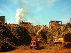
Waimea Canyon. Along the way, I stopped at the Gay & Robinson Sugar Mill and
took a tour of their facilities. This is one of only two remaining sugar
mills in Hawaii, the other being on Maui. I was surprised at the $30 tour
price but it turned out to be worth every penny. The two-hour tour first
took us out into the fields to see the planting, harvesting and burning of
the cane. Then we were issued hardhats and safety glasses and got a close-up
tour of the mill which operates 24-hours a day. The mill is powered by a steam turbine which is fueled by sugar cane stalks which have had the sugar pressed out. One of my favorite sections of the mill was the 10,000 square foot tank which is filled with up to 12 feet of molasses, a by-product of the process. By
11:00 AM, I was on the road again and drove past the cut-off for the canyon
as I wanted to see what was at the end of Highway 50 in Mana. Then I
returned along the coast to Kekaha where I headed up Waimea Canyon towards
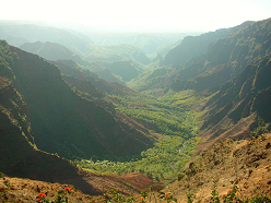
Kokee State Park. Waimea Canyon is a small version of the Grand Canyon, cut
deep into the island. Steep in most places exposing the colorful dirt of the
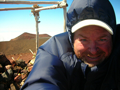
area, it is also covered with vegetation. I drove out to park headquarters and located where I would be camping tonight. Next, I picked out a hike which I was sure I could finish by dark. I hiked out the Nualolo Trail which descended steeply towards the ocean. After 3.4 miles, I turned north onto the Nualolo Cliff Trail which runs for two miles and is washed out in one place, requiring some extra concentration to get by. Then I took the Awaawapuhi Trail 2.8 miles back out to the road. Someone offered me a lift back to my car saving me the final two miles on the pavement. I pitched my tent at the Kokee Campsite, took a cold shower and read for awhile before going to bed at 7:00 PM. I slept for several two-hour periods and was glad I had my sleeping bag as it was much colder at this elevation. By 6:00 AM on Friday, I had struck camp and was driving out to the most northerly point of the canyon where I planned to hike the Pihea Trail. There were no other cars at the Kalalau Lookout when I parked at the roadblock and walked an additional mile on the paved road which is now closed to vehicular traffic. The Pihea Trailhead is at the Puuokila Lookout and traverses a ridge with the ocean on the north and the Alakia Swamp far below to the south. At 4,000 feet above sea level, this is the highest swamp in the world. I hiked out the Pihea Trail for a mile until I reached the Pihea Vista where the trail turns south and descends a steep section. Since I was alone and the trail was slippery, I decided not to continue down and after a half-hour of enjoying the views, turned around and returned to my car. On the way down Waimaea Canyon in my car, I stopped at several places to enjoy the huge waterfalls which cascade from the cliffs. I checked back into the Kauai Inn and spent the afternoon reading and doing some laundry. Saturday, I checked out and drove counter-clockwise along the coast up to Anini Beach Park on the North Shore. This is another beautiful camping area right on a sandy beach. I wanted to hike a little before setting up my tent so after some difficulty finding the trailhead, I started up the Power line Trail. This trail runs from the north shore town of Hanalei, through the interior for 13 miles to Lihue. A wildlife refuge is to the right side of the trail while the Moloaa Forest Reserve, a hunting area is to the left. Starting just before noon, I hiked up the unmaintained trail for about three miles. I had hoped to see the summit of Mt. Waialeale which receives 450 inches of rain each year making it the world’s wettest place, but it was enshrouded in clouds. I met several hunters, one of whom had just shot and butchered a boar. Hunters use dogs to flush out the pigs and then shoot them with big handguns. All I was able to see of the boar was a bulging knapsack of meat with the bleeding jawbone and two tusks strapped to the outside. After about an hour and a half I turned around and headed back down. I drove over to the tourist town of Hanalei before returning to my campsite and setting up my tent. My plan for Sunday was to hike the Kalalau Trail, a coastal route on the north shore which is assessable only by foot. But when I woke up it was pouring rain and the clouds extended as far out into the Pacific as I could see. I took the 20 mile drive out to the trailhead anyway, but finally decided that I would pack up my tent and move back to the comfort of the Kauai Inn on the other side of the island. I didn't hike Sunday or Monday and spent the time planning my Tuesday move to The Big Island. Hawaii is home to the state's highest mountain, Manua Kea at 13,796 feet and the second highest, Manua Loa at 13,677 feet. Considering that these two volcanoes rise up 18,000 feet from the floor of the Pacific, they form the world's largest mountain. You can drive to the summit of Manua Kea, but the hike up Manua Loa is a 40-mile round trip on foot. I packed up and left Kauai on Tuesday. I took a 10:00 AM flight back to Honolulu which connected to a flight to Hilo on Hawaii. November is the beginning of the rainy season in Hilo and sure enough it was raining when I arrived. I rented a car and drove over to a little place called The Wild Ginger Inn which I had read about. This is an old workers barracks of a sugar plantation which has been converted to a motel. They had cable TV and an internet connection so I was happy. Wednesday I ate breakfast and set out to drive up the Saddle Road to Mauna Kea. It continued to rain as I drove 35 miles up the gently sloping volcano which appears as a moonscape as a result of various lava flows. When I reached 8,000 feet I was above the clouds and the rain stopped. I continued to drive up to the visitor's center at 9,200 feet. Here the road becomes gravel and they strongly discourage continuing unless you have a 4WD vehicle, which I did not have. My main reason for coming here was to acclimatize for a planned hike up Mauna Loa tomorrow. I parked at the visitor's center and decided I would hike up a little towards the summit. Although there was no rain, the wind was horrendous. I hiked up about 1,000 feet before deciding I had had enough acclimatization and hiked back down along the gravel road. The road did not seem too steep and when I got back to the visitor's center, I spoke with a driver who made me feel I could make it up if I drove carefully, so I decided to try to drive to the summit. The road is five miles of gravel switchbacks followed by three more miles of paved inclines. Driving up, I could see why they discourage 2WD drive vehicles. Even in low gear, I had to stop every mile or so to let the engine rest. There are 8-10 large observatories around the summit of Mauna Kea, including two 10-meter Keck telescopes. It is renowned as the best place in the world to observe the heavens. But as I arrived on the summit, the wind was so strong; I could hardly open my car door. I drove a little closer to the University of Hawaii's Observatory which allows visitors and was able to struggle from my car into the visitor's gallery. The gallery was open but no one was there. I could see the huge telescope, but apparently most work here is done at night. The
actual summit of Manau Kea was a cinder cone about 200 meters from the
observatories. I debated whether I should attempt to go there, but finally
decided to don all of my clothing and head up. The wind was so strong that
I needed my hiking poles to keep from being blown over. I drove back down the mountain to the visitor's center stopping several times to let my brakes cool. At the visitor's center I watched a documentary about the conflict between native Hawaiian reverence for the mountain and the scientific community's interest in building bigger and better telescopes. Currently there is an ambitious plan to build a 30-meter Keck telescope which is being fought in the courts by the environmentalists and local people. After 3 hours on Mauna Kea I drove back down to Hilo and the rain. Since I hope to camp for the next few nights, I decided to treat myself to a nice dinner. Thursday, November 3rd, I checked out of the Wild Ginger Inn and drove up Route 11 to Hawaii Volcanoes National Park. I registered at the visitor's Center to climb Mauna Loa and camp for three nights in the cabins on its slopes. I drove out the beautiful eleven mile one lane Mauna Loa Road to Mauna Loa Lookout where I parked. The weather here at 6,500 feet was clear but a little windy. I planned to hike up 7 1/2 miles to the Red Hill Cabin where I would spend the night and then continue the additional 12 miles to the summit the next day. Starting at 11:00 AM, I hiked for about 2 hours, but it became very windy. I decided I did not have the right clothing with me to continue up beyond the point of no return so I turned around and hiked back down to my car. I felt a little guilty not to have completed my objective, but remembering how cold and windy I was yesterday on Mauna Kea, I did not want to be caught in such an exposed area. I drove back down the 40 miles to Hilo where, of course, it was still raining. I checked back into the Wild Ginger Inn and spent the afternoon doing laundry and planning my next couple of days. I moved out of the hotel again Friday morning and drove back up to Hawaii Volcanoes National Park. I found a campsite at Namakani Paio Campgrounds and pitched my tent. I walked over to the Kilauea Observatory and then hiked along the Crater Rim Trail to Volcano House where I ate lunch before returning to my campsite, a six mile hike. Although it was a beautiful day, I could see dark clouds covering Manau Loa, twenty miles away and was glad I was not up there. I spent the rest of the day reading and watching the campgrounds fill up.
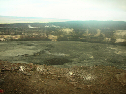
Saturday I awoke to a nice morning and decided I would hike the Crater Rim
Trail around Kilauea. I left at
6:15 AM, first hiking to the Observatory and then continuing
counter-clockwise. But when I came to Halemaumau Crater I had the
opportunity to descend down into the Kilauea Crater
I arrived at Volcano House at 9:00 AM. I decided I would sit by the famous fire in their lobby, which has been burning continuously for 75 years, and read. At noon I ate lunch in the cafeteria and then hiked back to my campsite. Early Sunday I packed up and drove 100 miles up the Kona Coast to Kailua, home of the Ironman Triathlon. I checked into Uncle Billy’s Kona Bay Hotel and spent the day lounging at the pool and wandering around the tourist town. Since I have so much more to see here on the Big Island, I decided to stay here another week and skip Molokai and Lania. I
spent two nights in
Kailua doing a short hike each day and having dinner at Outback
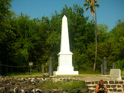
each night. My first day I drove up to the town of Captain Cook and hiked
two miles down a 1400 foot slope to the Captain Cook Monument. Tuesday I drove out to Waimanu and stayed at The Kamulea Inn. I was thinking about visiting the 250,000 acre Parker Ranch, but after reading their brochure, decided I was not interested in horseback or ATV tours, so I spent most of the afternoon reading. Wednesday I left Waimanu and drove to the Waipio Valley. I had hoped to hike here today, but it was raining and I decided to continue on to Hilo and return tomorrow when the weather was better. I drove on the coast road, completing my circle of the island and checked back into The Wild Ginger Inn. It is hard to believe that this entire island is formed by lava. I read that Manua Loa alone, excluding the other four volcanoes which make up the Big Island, contains 19,000 cubic miles of lava! The
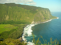
weather was better Thursday and I drove the 50 miles back out to The Waipio
Valley. My hike started with a 900 foot decent down a paved 2/3 mile road
which is only open to 4WD traffic due to the 25% incline. From the
base, I continued out to the beautiful black sand beach
When I reached the beach again, I came across a guy who had a bad injury to his leg and could not walk. He told me he had been there for two days hoping that his leg would get better, but it had only become worse. My cell phone did not work in the valley so I promised I would call 911 when I got to the nearest phone and perhaps they could send a helicopter to get him out. The ascent back up the 900 foot road was much harder than I thought, possibly because I was in a hurry and did not stop for rest. But I finally made it and went to a store where I called 911. I had to wait at the store for the rescue people so I could show them on a map where the guy was, but they arrived quickly and I was able to head back to Hilo by 2:30 PM. On the way back, I picked up a hitchhiker who told me that the Bayfront Road in Hilo had been closed yesterday due to a tsunami warning, but nothing had materialized. Friday I checked out of Wild Ginger and drove up to Hawaii Volcanoes National Park again where I planned to camp for the weekend. This time, I found a campsite in the Kulanaokuaika Campground and set up my tent. I drove out to the end of Hilina Pali Road and parked at the Lookout so I could hike down to the ocean. This trail descends a 200 foot cliff before reaching a 2-mile wide plain that slopes gently to the sea. I hiked eight miles over rough trails and countless lava tube caves. Coming back up the 2000 foot cliff was tiresome, but I completed the circuit in 4 1/2 hours.
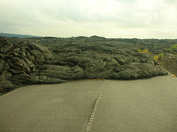
Saturday it rained so I spent the day exploring the park by car. I went to
the Thurston Lava Tube and drove down to the end of Chain of Craters Road to
where the lava has flowed over and closed it. I was anxious to get back to Hilo on Sunday as it had continued to rain throughout the night and I wanted to dry out. I watched a couple movies on Sunday and Monday and generally spent the time at the hotel planning my remaining nine days on Maui. On Tuesday, November 15th, I flew to Kahului Airport on Maui. I had spent some time in Lahaina training for the San Francisco Marathon twenty years ago and was anxious to see how the town had changed. I rented a car and drove 25 miles out to the western shore; only to find that the place I had stayed at in the 80’s was gone – replaced by million dollar condos. There are more resorts here now than ever before. Without a reservation, however, it was difficult to find a place to stay, until I was referred to someone who owns a couple of condotels and had a vacancy on which he offered me a great deal. I moved into The Lahaina Shores Beach Resort for three nights. I wanted to hike the Lahaina Pali Trail, an old horse and foot trail, which had been the original route from Kahului to West Maui, a hundred years ago. So on Wednesday I set out hiking 1600 feet up Kealaloloa Ridge and back down the other side. I did not want to hike all the way down as I needed to get back to my car so I turned around after about 3 miles and headed back the way I had come. I had started at 6:30 AM and was back at my hotel by 10:00 AM. It was very hot and I decided to sit out by the pool and read. In the afternoon, I walked through the old town of Lahaina to a grocery store where I bought some food for the next couple days.
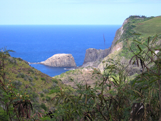
Thursday I drove north on Route 30 with the intention of
circling West Maui.
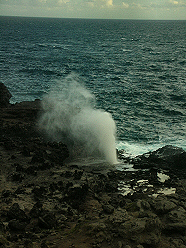
After driving for about an hour, I reached the northernmost point of the
island and the Nakalele Blowhole. I had read that the blowhole could spout
water anywhere from 0-75 feet, depending on the tide and surf. I hiked down
to the hole and was fortunate that the surf was pounding and the water was
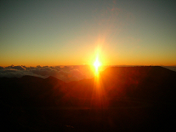
gushing about 50 feet. Further along, the road becomes a narrow one-lane way with many blind curves. My guidebook said it became gravel at this point, but apparently it has since been paved. Several times I had to stop and back up as I met oncoming traffic, and vice versa. When I reached Waihee Ridge, I parked and hiked up the Waihee Ridge Trail. The trail ascends 1500 feet in 2 ˝ miles up into the clouds where I could not see anything. After an hour and a half I reached the top and then headed back to the car and drove back to Lahaina. On Friday I had to check out of Lahaina Shores, so after doing some laundry in the morning. I headed over to Haleakala National Park. It is probably 35 miles from Kahului to the 10,023-foot summit. I planned to camp in the park for the next two nights and stopped at Hosmer Grove to set up my tent before continuing on to the summit. The top of the mountain was socked in with clouds and there was not much of a view. One of the popular activities here is to take a van to the summit and then ride a bike down the mountain to the bottom. A few diehards actually ride up the volcano and I met one named Benny who had arrived earlier and was dreading the long cold ride down. He jumped at my offer of a ride back to Paia where he had left his rental car. Benny told me his bike weighed about 12 lbs and cost several thousand dollars! After picking up some provisions for the next couple nights, I returned to my campsite and spent the rest of the evening reading. I had planned to get up to see the sunrise at the summit of Halekala on Saturday morning but was surprised to hear other campers in the area packing up to leave at 4:00 AM! Not wanting to miss anything, I threw together what I needed for the day and headed up with everyone else. Parking at the summit is limited to about 50 cars and it was half full when I arrived. The sun didn’t come up for another couple hours, but at least I had a great parking spot.
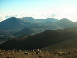
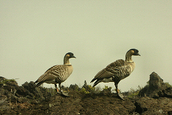
The sunrise was great,
I saw two pair of
Nene, Hawaii’s
endangered state bird, which came within a few feet of me as I hiked. Sunday, 11/20, I packed up my tent early and headed down off the mountain. I was able to check into the Maui Seaside Motel early. After showering, I went to the Maui Mall for a while, and then returned to the comfort of the pool. I stayed at the motel until noon on Monday when I checked out and drove 80 miles up the Hana Highway, past the town of Hana, to the small section of Haleakala National Park which borders the ocean. Referring to this road as a highway is a huge misnomer. Although it is paved, there are probably 15 miles, which is only one lane. It seems there is a blind curve every Ľ mile and with traffic flowing in both directions, it took over three hours to reach the park. I located a campsite near the ocean where I setup my tent and spent the afternoon reading.
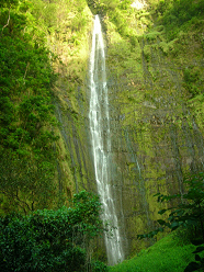
Tuesday morning I hiked up the Pipiwas Trail to
Waimoku Falls. The trail
ascends 900 feet through a bamboo forest to the falls, which drop 184 feet. On Wednesday I packed up my tent and drove back along the Hana Highway to Kahului where I reclaimed my room at The Maui Seaside. I didn’t need my rental car anymore so I turned it in a day early. It rained my last two days in Maui so I saw a couple movies. On Thanksgiving I flew back to Honolulu where I connected with my redeye to San Francisco. I plan to spend December in California with family, and then head to New Zealand in January. |
 but I wanted to wait a couple hours
for it to warm up a bit before I started hiking down into the caldera. I
planned a hike starting at the 10,000-foot level, hiking down 3,000 feet and
then returning up in another location to the 8,000-foot level where I would
hitchhike back to my car at the summit. Haleakala’s caldera is huge –
probably over 6 miles wide, and contains over a dozen cinder cones,
but I wanted to wait a couple hours
for it to warm up a bit before I started hiking down into the caldera. I
planned a hike starting at the 10,000-foot level, hiking down 3,000 feet and
then returning up in another location to the 8,000-foot level where I would
hitchhike back to my car at the summit. Haleakala’s caldera is huge –
probably over 6 miles wide, and contains over a dozen cinder cones,