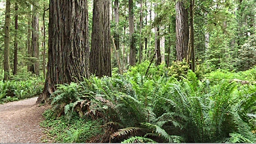
I stayed in Connecticut for a week after I stopped hiking the Appalachian Trail and then flew to California where I visited family until the end of June. On July 2nd, I borrowed a car from my parents and drove north to visit several national parks in the Northwest. I also hoped to connect with some friends I had met on various expeditions during the last couple years. I spent most of the first day driving up Route 5 to Redding and then cut over to Route 101 on the coast north of Eureka where I continued until I reached Redwood National Park at 4:00 PM. I decided to camp tonight and set up my tent in a State Park near Elk Grove. I saw several elk in the meadow before I had dinner. Saturday morning I
packed up and then took a 12-mile hike amongst the huge redwood trees.
For the first 10 miles I had the forest to myself. There were many
memorial groves dedicated to various people whom had apparently enjoyed the
area. Sunday, July 4th,
I had breakfast at the motel and then drove over to
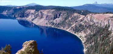
Crater Lake. I had been thinking about spending a couple of days hiking
around the lake, but there is not a trail that circles the lake – only a
road. I did spend a couple of hours hiking the few miles of trails that
were in the vicinity of the visitor center and I did get some great views of
the lake. There is still quite a bit of snow on the ground here. I visited
the Crater Lake Lodge and then around noon decided to head north to Mt. Hood. I drove for a few hours and then stopped in Redmond, Oregon where I checked into a Comfort Inn. Tomorrow I’ll plan to drive a couple more hours and stay at The Timberline Lodge on Mt. Hood. I really liked this Comfort Inn – it’s only a couple years old and has great amenities. One of the most interesting features was a self-service waffle maker at breakfast, which produced perfect waffles every time. I would come to discover that almost all hotels in the northwest have these machines; although it was the first time I’d seen them. On Monday morning I
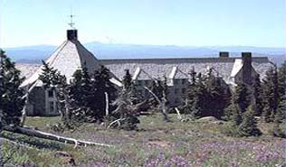
checked out at 7:30 AM and drove north to Mt. Hood. I had made reservations
to stay at
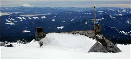
The Timberline Lodge;
a beautiful lodge built
I stopped to watch and photograph snowboarders going over a large jump
for a while and then met someone who had been part of a group that was
climbing to the summit today. She had turned around due to an
asthma attack but was expecting her group to
return soon.
Tuesday, July 6th, I checked out and drove over to Portland, Oregon. I had hoped to get together with Cory Nye whom I used to work with, but that will have to wait until I come back through in a couple weeks. I found another Comfort Suites and checked-in. I spent most of the afternoon on-line planning my upcoming trip to Asia. Wednesday morning I checked out and headed north to Seattle. I had to stop by the Portland Airport to pick up a ticket for an airline reservation I had made yesterday to China for the unbelievable price of $371 one-way. I continued up Route 5 and then turned onto Route 101 when I reached the Olympic Peninsula. Port Angeles is at the northern end of the peninsula and the drive up Route 101 was very scenic. I arrived in Port Angeles and after checking out a couple places to stay, I decided on a Best Western on the east side of town. For dinner, I had been invited out to the home of Steve & Kelly Oliver whom I met last year while climbing Mt. Kilimanjaro. They have a beautiful home about 20 minutes west of Port Angeles. I enjoyed a wonderful dinner of Dungeness crab and shish kebob while we caught up on our activities of the last year. They hope to climb Aconcaugua sometime in the near future so I was able to relate some of my experiences there last winter. Steve & Kelly gave me
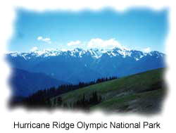
some great suggestions as to where I should go to get the most out of
Olympic National Park while I am here. I planned a couple one-day hikes
and a three or four day hike up over The High Divide into the Hoh Valley and up towards Mt.
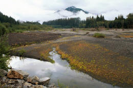
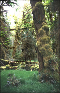
Olympus Base Camp. I got back to my hotel at about 11:00 PM. Thursday I got up and checked-out after another great waffle breakfast. I headed west to the coast where I planned to hike a ten-mile loop out to the ocean and back. The area is next to the Ozette Archaeological Site, once a village of Makah Indians, which had been inhabited for several thousand years. The village was entombed in a large mudslide several hundred years ago, which served to preserve many artifacts. The trail led through old growth forests and I saw some of the largest cedar trees that I have ever seen. I spent three hours on the trail, including an hour walking along the shore during low tide. Around noontime, I started back, driving along winding roads through logging country. Many of the mountainsides outside the national park have been clear-cut and are in various stages of reforestation. I had made reservations to stay at The Lake Crescent Lodge tonight, which I reached at 2:00 PM. My room has a great view of the lake. I used the afternoon to organize my gear for my camping trip tomorrow. I sat on the porch overlooking the lake and read for a couple hours before dinner. The lodge has an award-winning chef and I enjoyed a delicious salmon for dinner. Friday morning I met Steve at the lodge after breakfast and we headed out to the trailhead. He stopped to show me the hot springs on the way and I made a mental note to take advantage of them on the way back. We went to the visitor center and discussed various routes with the ranger and then bought a backcountry permit for the next three nights. Steve accompanied me for the first mile up to a beautiful waterfall and then I continued on my own. I
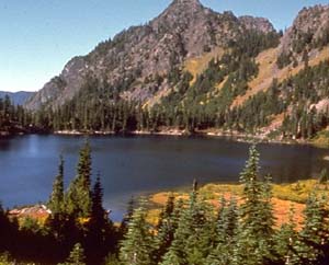
hiked about eight miles and most of it was uphill. When I reached Hoh
Lake,
Saturday, July 10th, I was awoken by the sound of hoofs charging through the campground. I looked out to find a herd of mountain goats prancing about as if we had all camped in their territory. The dozen or so goats were not at all intimidated by our attempts to shoo them away. I actually had to protect my gear from being eaten as I packed up. Today I planned to hike down into the Hoh Valley Rainforest and then up towards Glacier Meadows, the base camp for climbing Mt. Olympus. The first five miles were downhill to the Hoh River. When I reached the valley, I decided to pitch my tent so I could try to dry out some of my gear, and then continue on with a much lighter backpack. I hiked for about another hour until I had almost reached Elk Lake, at which point I decided to turn around and head back to where I had set up camp. At 2:00 PM it started
to rain again – not so unusual considering I was camped in a rain forest.
All my clothes were wet, along with my hiking boots, and it was all I could
do to keep my sleeping bag from getting wet. It got dark around 9:30 PM,
but I did not sleep too well this night. Sunday morning I had the tent down by 7:00 AM and had started the long uphill climb back to Hoh Lake and the High Divide. By noon, after taking several breaks, I had reached the highest point. I had originally planned to hike east along the High Divide and camp tonight at a place Steve had suggested named Silver Snag, which offered excellent views of Mt. Olympus. But the clouds covered the entire range and although it was not currently raining, I felt the sky could open up at any moment. I decided to forego my last night out and head back the way I had come up. This meant a 20-mile day, but the lure of a dry bed was too tempting to continue on for another night out. On the way down, I passed a couple rangers who were hurrying up and stopped to ask me if I had seen a group of 7-8 hikers. They didn’t say why they were looking for this group, but I was able to report that I had seen a bunch of people fitting that description about a half mile further up the trail. I got back to my car at 4:00 PM and quickly changed into some dry clothes for the one- hour drive back to Port Angeles. I checked back into the Best Western where I had stayed Wednesday. I’ll probably be here for two nights, which will give me a chance to visit Hurricane Ridge tomorrow and go over to Vancouver on Tuesday.
I checked out of The Best Western on July 13th and drove to the harbor where I took an 8:00 AM ferry to Victoria, BC. The one-hour ride on the Victoria Express was smooth and as we entered Victoria Harbor, two seaplanes were taking off nearby. Victoria is a beautiful city with flowers everywhere. I took a city tour and then went up to Butchart Gardens where I spent a couple hours wandering the 55-acre privately run showcase before heading back to the capital. In the afternoon, I visited the Fairmont Empress Hotel before catching a 6:15 PM ferry back to Port Angeles. The trip back was not as smooth as the morning voyage. We docked at 7:45 PM
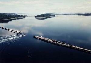
and I started to drive east on route 101 in search of a place to stay before
going on to Seattle tomorrow. Although I was delayed a couple times due to
construction, I crossed over the Hood
Canal Bridge
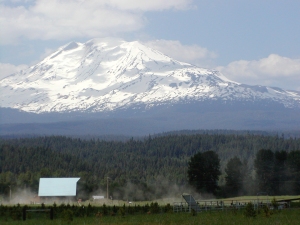
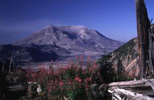
Wednesday I left Edmonds and drove 30 miles south to Seattle. I found a hotel near the Seattle Center and was able to check-in early. I walked to the Space Needle and then took a Greyline Trolley tour of the city. I spent a couple of hours wandering around the Pike Street Market and then went over to the IMAX Theater and watched a film on the eruption of Mt. St. Helens. In the afternoon, I took the trolley back to my hotel. I had originally planned to spend a couple of days in Seattle but changed my mind and checked-out Thursday morning. I drove on Route 5 south to Castle Rock and then headed east for an hour to The Johnston Ridge Observatory, overlooking what is left of Mt. St. Helens. The view into the northern side of the mountain, which had been blown away in the 1980 eruption, was fantastic. The weather was excellent and the entire pumice plain was clearly visible. The mountain is about 5 ˝ miles from the observatory. All of the trees on all of the surrounding mountains have been completely blown away. In the late afternoon, I drove back out to Route 5 and continued south to Woodland, where I found a place to stay for the night. Friday I checked-out
and drove east on Route 503 for over two hours to Windy Ridge where I could
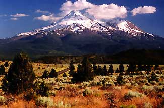
get a different perspective of the Mt. St. Helens eruption. I started my hike at 10:30 AM. The trail is not very steep and offers the interesting opportunity to hike on material, which was deposited as a result of the eruption. In some places this material is 650 feet deep. I had clear views to surrounding mountains for about 15 miles and there was not a tree in sight. The earth is slowly recovering though and there are wildflowers everywhere. After six miles, the Truman Trail intersects with the Boundary Trail where I continued for another 2 ˝ miles up to Johnston Ridge. Since I had visited the observatory yesterday, I did not stay long and turned around to head back. It was hot, but I had plenty of water. I saw many people hiking near the observatory, but I think I might have been the only hiker who crossed the entire pumice plain today. I got back to my car at 5:30 PM, drove back to Woodland and then continued south on Route 5 to Vancouver, Washington. I found a Staybridge Suites and checked-in for two nights. Aside from all the normal amenities, this hotel also had a free laundry for guests, a great breakfast and excellent service. I’m glad I don’t have to compete with this place in the corporate housing business. Sunday morning I checked-out and drove a few hours south to Medford, Oregon. I wanted to visit the Harry & David headquarters, which was not open today so I found another place to stay and checked-in for the night. I spent most of the afternoon reading. On Monday morning, I checked-out and went to the Harry & David Country Store which was behind my hotel. A tour bus leaves for the headquarters and factory, which are a couple miles away. The tour was only an hour long, but was interesting nonetheless. At 11:00 AM, I left Medford and drove south on Route 5 to Mt. Shasta. Here I found another place to stay and then drove over to the Forest Service office to get information on climbing Mt. Shasta. At 14,162 feet, Shasta is the second highest volcano in the US. I found I would need crampons and an ice axe to climb to the summit, so I settled on a day hike up to about 10,000 feet. I’ll plan to hike up tomorrow morning. In the afternoon, I walked around the tourist town of Mt. Shasta City, ate lunch and visited an Internet café.
I continued up Avalanche Gulch another 1,200 vertical feet until I reached the snow. I could have continued another 1,000 feet to the 10,000-foot level but did not want to hike on snow alone. A climbing permit is required above 10,000 feet. I met a guy from Florida on my way up and shortly thereafter found a camera on the side of the trail. Although he had left by the time I returned to Horse Camp, he had signed the guest register so I was able to track him down and send his camera back to him. By 10:30 AM I was back at Bunny Flat where I drove back to the hotel. I showered and checked out by noon. I decided to spend the rest of the day driving back to Novato instead of staying out another night. I’ll spend a week with my dad before flying to Shanghai to meet my mom & sister who are currently touring China. |