 |
Western National Parks May 2009 Journal |
|
|
Western National Parks May 2009 Journal |
|
On Monday, May 4th, we packed our suitcases and camping gear and
headed back out on the road. We plan to visit and camp in six National
Parks during the next three weeks, punctuated by a 5-day stay in Las Vegas.
We drove south to
Tuesday morning we drove the final hour up Route 140 to the national park.
At one point along the twisting road, a large landslide covered the road and
a couple temporary bridges had been installed so traffic could continue on
the other side of the river to clear the slide. We arrived in Yosemite
before noon and checked into our tent cabin in Curry Village for the next
three nights.
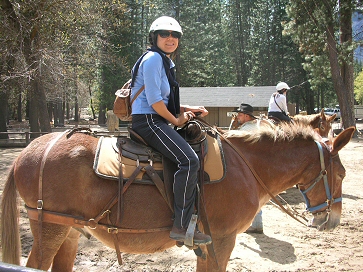
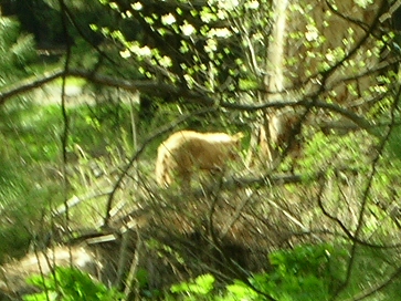
The two-hour mule ride to Mirror Lake was a great success and Cindy had a
wonderful time. I had seen a bear during her ride, so we went back and sure
enough, it was still there. For dinner, we ate at Yosemite Lodge under the
falls, and then went to see a one-man theatrical show about John Muir in the
Visitors Center.
Wednesday we awoke at 6:00 AM with plans to hike up to the base of
Half-Dome. I have done this hike twice before and recalled that it took
about six hours, which is what I had told Cindy. I was younger and in much
better shape when I last hiked it though, and a ranger told us it was really
a 12-hour hike. This news was very discouraging to Cindy and after only an
hour of hiking, she decided to go back while I continued. I took the Mist
Trail up alongside Vernal Falls. With the water raging the way it was, the
trail was quite treacherous and I was glad that Cindy had turned around. By
the time I reached the top of the falls, I was drenched. Continuing along
the switchbacks on the west side of the river, I reached the top of Nevada
Falls before
Cindy had taken a tour of the valley floor and visited the museum while I
was hiking. We decided to have a picnic at Glacier Point so we drove out of
the valley and up Route 41 towards Wawona. On the way we stopped at the
base of El Capitan and watched ant-like climbers half
Thursday we walked over to The Ahwahnee Hotel where we ate breakfast in
their spectacular dining room. The hotel also offers Internet access, so I
was able to spend a few hours catching up while Cindy went on a ranger-led
walk. At noontime, we met up again at the Ahwahnee where we took a tour of
the historic hotel. We ate dinner again at Camp Curry and then took the
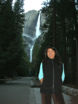
shuttle bus to Yosemite Falls where we walked up to see the lower falls. I
did not realize that this is the highest falls in the USA. The light was
leaving the valley, but I was able to get some good photographs before going
home.
Friday we checked out and drove over to The Ahwahnee for coffee and one more
session on the Internet. By 8:00 AM we were on the road south towards
Fresno where we would turn east on Route 180 to Kings Canyon and Sequoia
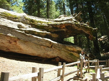
National Parks. We arrived at Grants Grove Visitor Center by 11:00 AM and
hiked a two-mile loop to Grants Grove to see our first sequoia trees.
some supplies at the market and drove 30 miles to Roads End where we found a
nice campsite for the night at Cedar Grove. Only one of the camping loops
was open, but we did not have difficulty locating a site not too close or
far from the restrooms. We entertained ourselves playing cards until
nightfall, and then turned in for our first real night of tent camping. Saturday morning we packed up everything except our tent and food, which we left in the bear box and drove six miles to the trailhead where we started hiking up towards Paradise Valley. We were the only people on the trail and just before the turnoff to Mist Falls I got a fleeting glimpse of a bear on the trail ahead. At Mist Falls, we continued upward in hopes of seeing a huge logjam on the river, which had amazed me the last time I was here about four years ago. But we tuckered out before reaching Paradise Valley and turned around at about the six-mile point and retraced our path back to the car. By 11:30 we had returned to Cedar Grove; packed our tent and food and were driving out of Kings Canyon. We passed Grants Grove and continued another hour down to Sequoia National Park where we stopped at Lodgepole Visitors Center. Most Lodgepole campsites are still closed, but we were able to find one near the river where we set up our tent, and then went back to the visitorĺs center to shower and wash some clothes. Also in the laundry were a couple from The Netherlands who were on a very similar trip as our own; San Francisco, Yosemite, Kings Canyon/Sequoia, Las Vegas and then LA and back up the coast to San Francisco. When our laundry was complete, we drove over to the Wuksachi Lodge where we made a reservation for Sunday night and then spent a couple hours in their facilities. We also ate dinner at the lodge before returning to our Lodgepole campsite after 8:00 PM.
I didnĺt sleep well Saturday night, but Cindy is really getting used to
sleeping on the ground and slept right through the night. We packed up all
but our tent and food and left the campground at 7:30 AM and drove down to
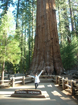
see the General Sherman Sequoia Tree.
We stopped at the Giant Forest Museum for a half-hour before returning to pick up our tent and food before checkout time at noon. We were fortunate to be able to get into our room at the lodge when we arrived and spent the rest of the afternoon relaxing in the lodge before eating dinner in the restaurant.
Monday morning we ate and checked out early for our 7-hour drive to Death
Valley National Park.
Tuesday morning, we got coffee at the general store, and then set off to
explore. We drove east on Route 190 to Zabriskie Point where we got a good
view of the Badlands. Continuing another fifteen miles, we reached
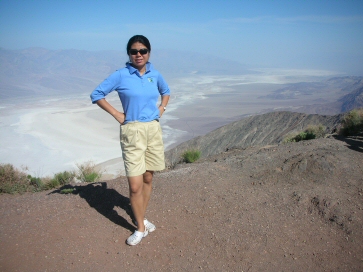
Danteĺs View, a mile-high viewpoint overlooking the entire valley. Although
it was only 9:00 AM, the temperature was probably about 100 degrees, and the
steep ride up the mountain caused my radiator to overheat. Returning to the
visitorĺs center, we viewed their various exhibits, movies, and
souvenirs for sale. After using their wi-fi, we did a couple loads of
laundry and then ate lunch with a couple hundred French tourists. In the
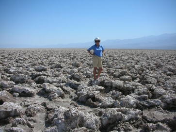
afternoon we set out again, this time on the road to Badwater. At 282 feet
below sea level, Badwater is the lowest point in the Western Hemisphere.
We went for a swim in the pool Tuesday afternoon and then ate dinner. Wednesday we will drive to Las Vegas where I am scheduled to play in a tournament this weekend at The Palazzo. Las Vegas We spent five nights at The Palazzo in Las Vegas. Our suite was beautiful and overlooked the strip where we could see the pirate show at Treasure Island several times each night. We ventured over to The Wynn one night to see La Reve, their large production water show, which was interesting but not overwhelming. I tried to go to the gym each day and we would often spend some time at the pool. The weather was good and the temperature near 100 degrees. I took our car over to a Ford dealer, which kept it overnight and repaired a faulty tank on the radiator. The tournament was fun, but I did not win anything. Cindy had won a couple tickets to see Blue Man Group, where we had planned to go after the awards ceremony on Sunday night, but I became very ill and we returned to the room. My illness came on suddenly just after dinner, so I think it must have been something I ate during the awards dinner. We checked-out of the hotel Monday morning and started driving northeast on Route 15 towards Salt Lake City. I still was not feeling 100% so we drove until I became too tired and then stopped at a Comfort Inn in Ridgefield, Utah. Tomorrow we will continue on to Arches National Park.
We arrived at Arches National Park around 11:00 AM. After going to the
visitorĺs center for an hour to get an overview of the park, we decided to
drive into Moab to get lunch and buy some food for dinner before driving the
20 miles out into the park to our campsite. Moab is a nice little town
geared to tourists with lots of hotels, restaurants, and outdoor
activities. We ate at Dennyĺs, picked up some fruit at City Market and then
returned to the park where we climbed the canyon road to the Devilĺs Garden
Campground where we had reserved a space for the night. The campground was
fully booked, but the campsites are very private so it did not feel like
there were many people there.
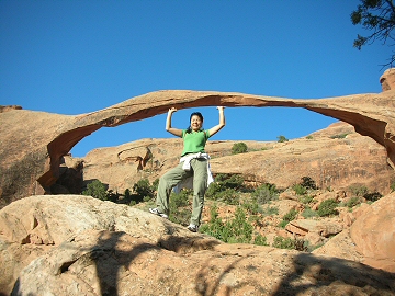
After setting up our tent, I was anxious to hike out to see Landscape Arch. The weather was worsening and I could see lightening on the horizon, but the forecast for tomorrow is for thunderstorms and I didnĺt want to miss the chance to see the largest arch. Cindy didnĺt want to hike in bad weather so I hiked out alone. As I approached the end of the trail, it did start to rain and the wind became gusty blowing sand in my face. But seeing the arch itself was worth the trip, and after taking a few photos, I hurried back to the car.
In the evening, we drove over to see Delicate Arch, one of the parkĺs icons,
and then stopped at several viewpoints on the drive back to our campsite.
We left Arches National Park by 10:00 AM and drove to Moab where we were able to drop some luggage at The Sleep Inn where we had booked a room for Wednesday night. Continuing south, we drove two hours to The Needles, one of three areas of Canyonlands National Park. This area seems geared mostly to 4-wheel drive vehicles, but offers some spectacular views and landscapes. After a stop at the visitorĺs center, we drove out to the end of the road where we took some photos and then headed back to Moab. After soaking in the hot tub for a while, and doing our laundry, we drove over to a local adventure outfitter to inquire about a white-water rafting trip. We donĺt have time to go this time, but may return here in July. For dinner, we ate at The Branding Iron, a local steakhouse.
Thursday morning we checked out of The Sleep Inn and drove north through
Moab and then south to Island in the Sky, Canyonlandĺs most accessible
area. At the visitorĺs center we listened to a half-hour presentation on
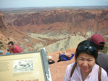
uranium mining. We drove on to Grand View Point Overlook where another park
employee was giving a talk on the geology of the area. Years ago, I
remember being so impressed with the qualifications and knowledge of U.S.
Parks Service employees, but the people we heard today offered only canned
presentations and had little or no knowledge to answer questions. Grand
View Overlook is certainly impressive and reminded me of The Grand Canyon.
We left Canyonlands around 1:00 PM and drove back towards Moab so we could take the scenic drive along the Colorado River northeast to connect with Route 70. The forty-mile road follows the river and has numerous camping sites along its course. For much of the drive an optical illusion seems to make the river flow uphill, due to the heightening cliffs. We passed several groups rafting on the river and decided we might want to return here to camp if we return in July. We arrived in Grand Junction around 3:30 PM and checked into a Quality Inn where we had made a reservation. We had a great dinner at WW Peppers, just a few blocks from the hotel, and then returned for the evening. Friday we had rain for our final three hour drive to Breckenridge, CO. I had never driven to Breckenridge from the west and enjoyed the beautiful Rocky Mountain passes as we approached and drove over Vail Pass. We arrived at our studio apartment, named The Safari Suite, in the early afternoon. After getting settled, we went to the grocery store and then stopped by the Post Office to get a mailbox for the summer. Cindy made dinner and I spent the evening anxiously watching the dispatches from Mt. Everest where my friend Stephen Coney was making his final summit push in miserable conditions, but reached the summit at 7:30 AM Nepal time. Congratulations Stephen! |
 Mariposa,
California where we checked into a Quality Inn outside Yosemite National
Park. We ate dinner in a local restaurant and then stocked up on last
minute items we might need for camping.
Mariposa,
California where we checked into a Quality Inn outside Yosemite National
Park. We ate dinner in a local restaurant and then stocked up on last
minute items we might need for camping.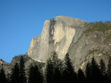
 9:00 AM
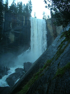 way
up the wall. The road to Glacier Point had just opened yesterday and we
encountered 4-foot snowdrifts, which had been plowed up onto the side of the
road. When we reached the end of the road, we walked out to the point to
look over Yosemite Valley, and then ate our sandwiches in a picnic area
directly across from Half Dome. On the way back, we stopped at Bridal Veil
Falls where we were drenched again by the spray of water cascading down the
cliff. After a couple hours rest, we ate dinner at Camp Curry.
way
up the wall. The road to Glacier Point had just opened yesterday and we
encountered 4-foot snowdrifts, which had been plowed up onto the side of the
road. When we reached the end of the road, we walked out to the point to
look over Yosemite Valley, and then ate our sandwiches in a picnic area
directly across from Half Dome. On the way back, we stopped at Bridal Veil
Falls where we were drenched again by the spray of water cascading down the
cliff. After a couple hours rest, we ate dinner at Camp Curry.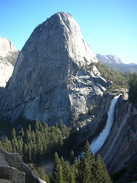
 After
lunch at the restaurant, we
After
lunch at the restaurant, we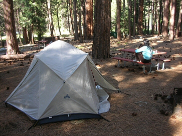
 Afterwards,
we continued through the back roads of the Giant Forest where scores of
other huge sequoia trees grow. This area had as many as 300 buildings to
accommodate tourists up until about 15 years ago when it was determined that
the overuse of the forest was inhibiting the health of the trees. The
buildings were all removed and Wuksachi Lodge was built outside the Giant
Forest to accommodate guests. We drove through the Tunnel Tree and then
parked at Moro Rock
Afterwards,
we continued through the back roads of the Giant Forest where scores of
other huge sequoia trees grow. This area had as many as 300 buildings to
accommodate tourists up until about 15 years ago when it was determined that
the overuse of the forest was inhibiting the health of the trees. The
buildings were all removed and Wuksachi Lodge was built outside the Giant
Forest to accommodate guests. We drove through the Tunnel Tree and then
parked at Moro Rock
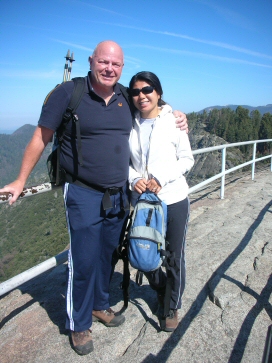 where
we climbed 350 steps to the top of this large, very pronounced granite
outcropping, which commands a 270-degree view of the surrounding valleys.
To the west, smoke from the fires burning near Santa Barbara could be seen
on the horizon.
where
we climbed 350 steps to the top of this large, very pronounced granite
outcropping, which commands a 270-degree view of the surrounding valleys.
To the west, smoke from the fires burning near Santa Barbara could be seen
on the horizon.
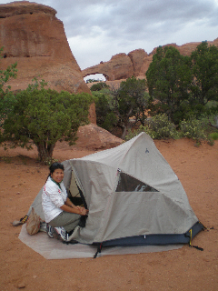 Our
site has some large sandstone fins, which tower over a shady, sandy flat
area where we set up our tent. We have a god view of Skyline Arch, about
300 meters away.
Our
site has some large sandstone fins, which tower over a shady, sandy flat
area where we set up our tent. We have a god view of Skyline Arch, about
300 meters away.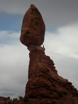 At
Balanced Rock, we photographed a tourist who had climbed up to the base of
the balanced rock itself, certainly against park rules. The weather cleared
and we slept pretty well. I was up before six and took down as much as the
camp as possible while Cindy slept. When she finally woke up at 7:00 AM,
she wanted to see Landscape Arch so we hiked back out there together and
took more photos.
At
Balanced Rock, we photographed a tourist who had climbed up to the base of
the balanced rock itself, certainly against park rules. The weather cleared
and we slept pretty well. I was up before six and took down as much as the
camp as possible while Cindy slept. When she finally woke up at 7:00 AM,
she wanted to see Landscape Arch so we hiked back out there together and
took more photos.